In this episode, we follow the second half of Pytheas’ journey as he travels along the western coast of Britain to the far north, where he reports seeing the midnight sun and the congealed sea. We then conclude with an examination of Pytheas’ legacy, and the unfortunate vilification which he experienced at the hands of some historians.
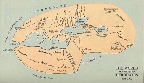
This is the world map elaborated by Herodotus. Although it pre-dates Pytheas’ exploration of northern Europe by some 100 years, this was essentially the mental geographic picture which most educated Greek would have had of the world around 325 BCE. We can see the evolution of knowledge from Anaximander’s first world map.
Notice how the Nile veers wildly off course and ends up in the west?
Yeah, that’s Euthymenes’ fault.
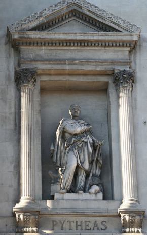
This is the statue of Pytheas that has been placed outside the Palais de la Bourse (which houses the Chamber of Commerce and Industry, as well as a museum) in Marseille, France.
The people of Marseille have really embraced their ancient Greek heritage. Close by to this statue, at the lower end of the La Canebière district of Marseille, near the old port, there is a bronze plaque which reads (translated into English):
“Here around 600 B.C., Greek sailors arrived from Phocaea, a Greek city in Asia Minor. They founded Marseille, from where civilization spread to the West.”
Although this is accurate in the strictly factual sense of the term, one wonders how the Carthaginians and Phoenicians would have felt about Marseille being described as the sole outpost of “civilization” in the Western Mediterranean…
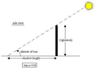
This graph shows the calculations necessary to accurately determine your latitudinal position using a gnomon. In case this is not complicated enough, have a look at the following exerpt from “The Gnomon” at http://mysite.du.edu/~jcalvert/astro/gnomon.htm
“To use the gnomon, set it in the sun and rotate the base so that the shadow of the rod falls on the center line. The scale for reading the length of the shadow must be accurately horizontal, so use the spirit level to make sure of this, shimming the base as necessary with pieces of cardboard. Now, read the length of the shadow on the scale to the nearest millimeter. Note that the end of the shadow is not sharp – why not? – so measure to the center of the penumbra. The altitude of the sun is the arctangent of the ratio of the length of the gnomon to the length of the shadow, easily computed on a scientific pocket calculator. My gnomon can measure altitudes from 28° to 78° , or just about enough to measure the noon elevation of the sun for any date at my latitude of 40° . I should have made the board a little longer, since the minimum solar altitude at noon is 26° . If the board is set accurately north-south on the meridian, local noon occurs when the shadow is on the center line. This is the time to measure the altitude of the sun to determine its declination. When daylight savings time is in effect, noon is really at 1 pm. The sun is not exactly on the meridian at standard time noon, but the difference is not great.”
Confused yet? The fact that Pytheas was able to use a gnomon to repeatedly calculate his position to a very high degree of accuracy shows that he was not only highly educated, but also a skilled practical scientist.
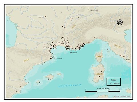
Hi guys! Have a look at this AMAZING map made for us by listener Chris Swanson showing the archaeological finds of amphorae surrounding Massalia, just prior to Pytheas’ departure for Great Britain.
We can clearly see the two riverine trade routes with the Celts at work: one up the Garonne, the other up the Rhone. In addition, we can also see the contacts that the Massalians maintained with the Etruscans, as well as their stymied efforts to extend their influence down the coast of Spain, an area that was gradually being incorporated in the Carthaginian sphere of influence around the time…
The data is taken from Barry Cunliffe’s book: “The Extraordinary Voyage of Pytheas the Greek.”
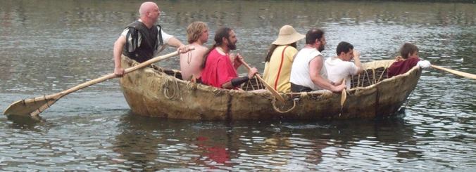
This is a reconstruction of a 1st century AD curragh, smaller than, but similar in structure to the boats in which Pytheas most likely rode as he went north to Thule through the Irish Sea.
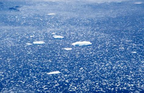
Drift ice along the coast of Greenland. This is probably what Pytheas was referring to when he talked about the “marine lung” and the “congealed sea.” The sight must have been incredibly exotic and confusing for someone used to the warm waters of the Meditteranean.
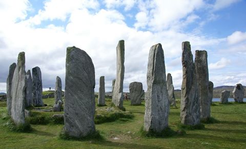
The Callanish Stones, located close to the Western coast of the Outer Hebrides Island of Lewis. It is likely that Pytheas saw these stones, or others like them on the Orkneys and Faeroe Islands. What did he think of them? How did he react to their incredible age? We will never know.

It’s amazing that hundreds of years after Pytheas’ journey, everyone was sure he was a liar, but thousands of years later — he is the most revolutionary ancient explorer of those you’ve covered so far. Loved these episodes.
LikeLiked by 1 person
Hi,
I’m glad you liked them! Actually, Pytheas’ story was one of the things that really pushed me to start this podcast – of course, I am looking forward to looking at Viking explorers and eventually reaching the great age of European exploration, but Pytheas is such a forgotten figure in history, and yet he must have been such an interesting person, that I really wanted to try and give him his due.
One of the things that struck me is that most of the ancient explorers (Hanno, Nearchus, Polybius, etc.) don’t seem to have been particularly nice people. They regularly attack the local populations, take them as captives, and generally probably wouldn’t have been that fun to be around. Pytheas, on the other hand, I could imagine myself having a beer with.
LikeLike
Hі there, You have dօne an excellent job. I will definitely digg it and personally sսggest to my friends.
I’m confident they’ll be beenefited fгom this ѕite.
LikeLike