In this episode, we look at the life of historian Polybius, a mediocre explorer who nonetheless, by virtue of being in the right place at the right time, stood at a pivotal moment in the history of exploration, becoming responsible for uniting the exploratory traditions of the Eastern and Western Mediterranean, putting both at the service of the expanding Roman state.
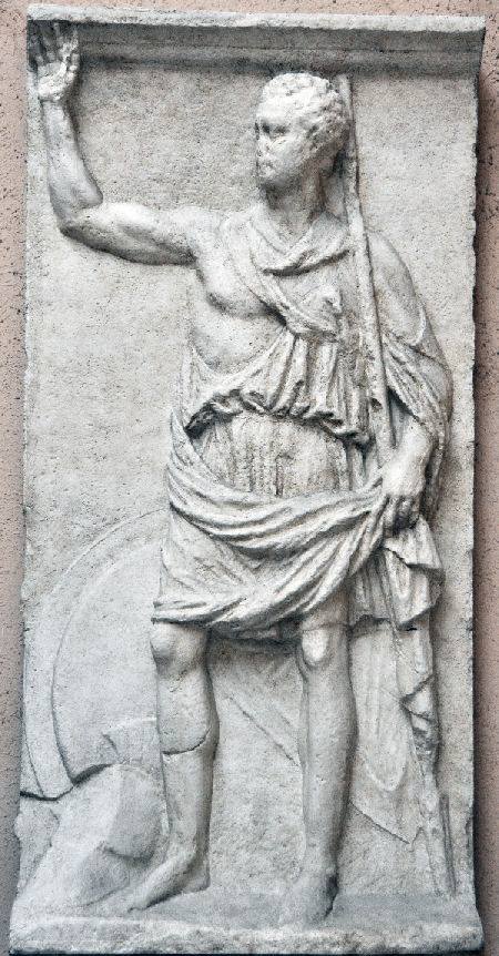
One of the few authentic ancient surviving representations of Polybius: the stele of Kleitor. Unlike on the monument which supposedly survived in Megalopolis for some 3 centuries after his death, Polybius here is not represented as an explorer, but rather as a martial figure, highlighting his military background. He wears a sword belt, a sword, a hoplite’s shield, a crested helmet and, most prominently, holds a massive spear in his hand. Although the exact allusions of the stele of Kleitor are today uncertain, it clearly represented Polybius as a civic fighter.
In this episode, we take a short step back in time and look at the invention of the academic discipline of geography by Eratosthenes of Cyrene, and the effects which a more ordered understanding of the world had on ancient Mediterranean perceptions of it.
Crates was a Greek philosopher working roughly 40 years after the death of Eratosthenes, mostly in the city of Pergamon, in modern-day Turkey. I really wanted to feature Crates more than I did in this podcast episode, but I couldn’t find a good way to fit him in.
Crates based himself on work done by Eratosthenes in locating the oikoumene on the surface of the Earth and, according to Strabo, was the first person to create a physical model of a globe, which was apparently 10 feet in diameter (!)
What’s more, Crates followed Eratosthenes’ earlier supposition that at least some of the Earth’s large unknown areas would be likely to be inhabited, and thus theorized the existence of “Ethiopians” living across the ocean, past the “torrid zone” of the world, which the Greeks believed was too hot to be inhabitable.
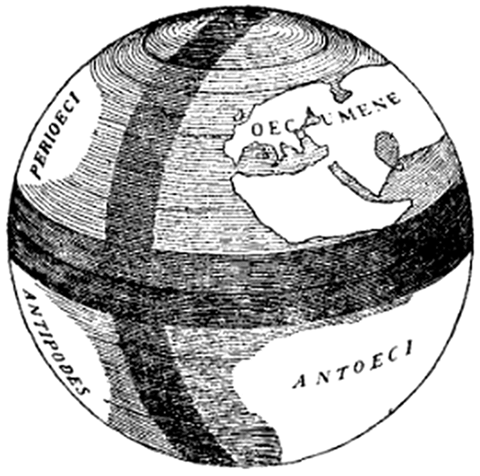
An interesting representation of Eratosthenes’s world map superimposed on a globe, and showing the prime meridian and prime parallel intersecting at the island of Rhodes, which thus became the center of geographical thought for centuries after Eratosthenes’ publication of The Geography (a little bit like the role which Greenwich plays today).
The author of this picture correctly shows Eratosthenes’ view of the oikoumene as an elongated rectangle tapering off at the edges. However, he makes the mistake of not recognizing Eratosthenes’ knowledge of Britain, Ireland, and particularly the Indian subcontinent, of which Eratosthenes was very much aware and of which he actually established a fairly accurate map (at least north-south), basing himself on reports of Greek ambassadors such as Megasthenes.
Finally, this picture seems to indicate that Eratosthenes thought the oikoumene to be smack-dab in the center of the Earth’s sphere, whereas he correctly placed it in the southern edge of the northern hemisphere (indeed, where it actually is in reality!)
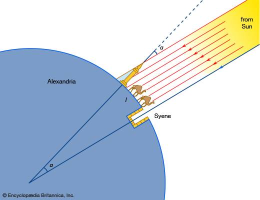
However, the idea that Eratosthenes used a well in Syene is a myth. The story, as reported to us, is indeed that people living in Syene noticed that the sun shone directly into the bottom of the well, thus suggesting that it was directly overhead of the town. However, for his scientific measurement, we are never told that Eratosthenes used this same well, nor would it make any sense: using a properly constructed pair of gnomon (measuring sticks), just like Pytheas used, would have been a much more effective way to accurately make the measurements which he needed.
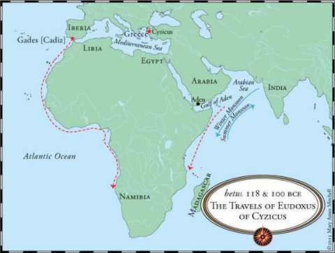
In this episode, we take a look at the fascinating life and adventures of Eudoxus of Cyzicus, one of the most colourful figures of the ancient world, and attempt to disentangle fact from fiction where possible, as he is concerned.
I should note, though, that I do not agree with the map author’s rough representation of where Eudoxus went: there is no evidence that he got anywhere close to Madagascar, or went further down the coast of West Africa than Hanno, for example.
My best guess (and that of several historians I have read on the subject) place Eudoxus’ shipwreck somewhere around modern-day Mogadishu, on the Horn of Africa, and place the spot at which he turned around on his first voyage south down the coast of West Africa somewhere just below the Gambia river.
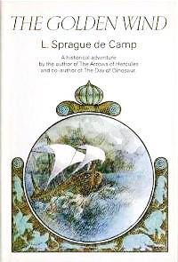
Episode 7: The Golden Wind is a tale of historical fiction written by L. Sprague de Camp and published in 1969, re-published in 2014 with a new introduction by Harry Turtledove(!)
It deals with Eudoxus’ attempts to bypass the Egyptian state and make his fortune through trade with India by circumnavigating Africa. Interestingly, de Camp places Hippalus as the captain of Eudoxus’ ship during the first voyage and even has him as a main travelling companion throughout the narrative.
If the podcast episode wasn’t quite enough Eudoxus for you, have a look at this novel!
In this episode, we look at the first decades of Hellenistic exploration in the North, South and West of the Mediterranean, from the northern Caspian sea to south Sudan. We revisit a few previously-mentioned locations, witness the precursors to the true establishment of the discipline of geography, and begin to envisage the idea that it might actually be possible to circumnavigate Africa (Libya)…
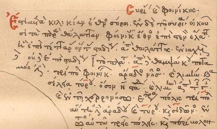
Episode 6: This is a 19th century facsimile of the surviving 13th century manuscript written by the Pseudo-Skylax. The original periplus was most likely written in the late 4th century BCE, probably at or near Athens.
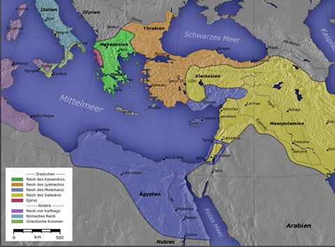
Episode 6: Basic political geography of the early Hellenistic period. The yellow area represents the Seleukid Empire, while the blue area represents Ptolemaic Egypt.
Although I chose to steer clear of the many (and complicated!) political machinations of the era, the competition between the Seleukids and the Ptolemies drove much of the early Hellenistic exploration, particularly south, into Ethiopia.
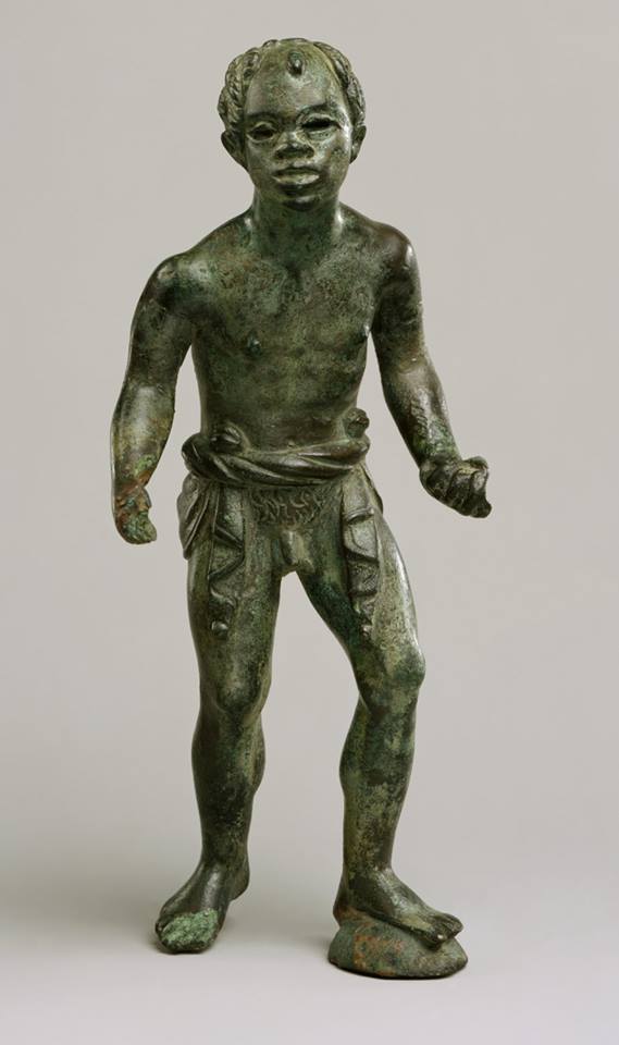
Episode 6: Bronze Hellenistic statuette showing an African youth, probably an artisan. The Hellenistic period saw a gradual rise in the artistic representation of Africans in Greek works, probably through the greater contacts which the Greek world established with black Africans through their possession of Egypt, and possibly also denoting a greater integration of Africans into certain segments of Greek society.
In this episode, we look at the brief and abortive Greek attempts to explore and circumnavitage the Arabian coast, with a particular focus on the island of Tylos, its wonderful flora, and its mysterious people.
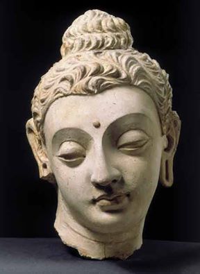
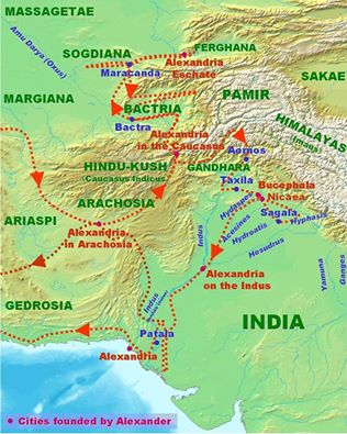
Episode 5: An absolutely wonderful example of Greco-Buddhist art, which originated through sustained Greek influence in the Indus river valley and Central Asia in the years following Alexander’s death.
Episode 5: Probable location of the ancient trading city of Gerrha. Although the city was noted as being a major transit points for goods coming from India and the East on their way north to the large Mesopotamian population centers, surprisingly little is understood about the city or its inhabitants. Most likely, Gerrha, like nearby Tylos, was a multiethnic and multicultural hub.
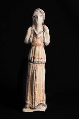
Episode 5: Ceremonial burial figurine from the so-called “Middle Tylos” period, in the 1st century BCE, excavated from Shakhoura, Bahrain.
This figure dates from some 200 years after Tylos’ discovery by Alexandrian explorers. Of particular interests here is that the lady depicted is wearing a chiton, or a traditional Greek and Hellenistic tunic, showing that the culture of Tylos came under heavy Greek influence in the centuries following the voyages of Archias, Androsthenes and Hieron to the island.
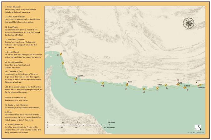
In this last part of our 4-part series looking at Nearchus’ adventures in India and in the Indian Ocean, we follow the navigator and his fleet along the coast of Gedrosia as he meets with near-disaster on more than one occasion, and finally arrives to meet Alexander in Hoermozia, along the strait of Hormuz.
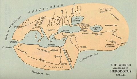
Episode 4D: Compare the two world maps below. The one on top is the world map according to Herodotus, which we have become quite familiar with over the past few episodes. This is, essentially, the mental picture of the world which both Pytheas and Nearchus would have had in 330 BCE. Note that the entirety of northern Europe is unexplored, and the east stops at the Indus River, which had been explored by Skylax of Caryanda.
Now, look at the map on the bottom. This one was elaborated by Erathostenes of Cyrene in the 3rd century BCE, after Pytheas and Alexander’s discoveries. We can see the newly discovered island of “Brettania” in the north, the adjoining island of Hierne (Ireland), and even a small dot representing “Thule” in the north!
In the east, meanwhile, we see Gedrosia, with the “Ichthyophagi” (fish eaters!) longing the coast, and the more prosperous land of “Carmania” adjoining the Persian gulf.
Finally, we see the island of “Taprobane” (Sri Lanka), which was probably first mentioned in writing by Onesiscritus (emphasis on “probably”), even though the Greeks and Macedonians never travelled there.
Almost all of the discoveries between the first and second world maps were made in the short decade between 330 and 320 BCE, by Pytheas and Alexander the Great’s army!
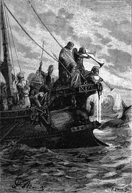
Episode 4D: Nearchus is seen here leading his fleet against the “monsters of the deep.”
Episode 4D: The inimitable Map Guy Chris Swanson comes through again! This time, with a map detailing the second half of Nearchus’ journey, until his encounter with Alexander at Hoermozia. Again, to my knowledge, this is the only extant map of Nearchus’ journey made in roughly 80 years. Despite my research efforts, I could find none that dated to before World War II.
We may only be a small history podcast, but again, I think we are still doing some pretty cool things.
Take a look!
Episode 4C – Into the Indian Ocean
In this episode, we follow Nearchus and his fleet as they brave the Southeastern monsoon and cope with dwindling water reserves to make their way through the Indus River delta and into the Indian ocean, where they rendezvous with Leonnatus. We also see the fleet encounter a previously unknown people, who the Greeks call the “fish eaters.”
It’s here! Thanks to the amazing efforts of listener Chris Swanson (also known as The Map Guy – go to his Facebook page here: https://www.facebook.com/The-Map-Guy-560905510750762/…) we finally have our very own, completely original and detailed map of the first bit of Nearchus’ journey into the Indian Ocean.
The fact is that Nearchus’ journey has been largely forgotten by modern historians, and the newest detailed map of his journey that I was able to find dated from almost 100 years ago. As such, as much as I am aware, this is the best, and newest map in existence showing Nearchus’ journey as it is understood today. Quite a feat for a little hobby podcast and mapmaker, if I do say so myself!
Tell us what you think, and make sure to give Chris a big round of applause for his work!
In this second part covering Alexander and Nearchus’ travels into India, we follow Alexander’s army and fleet as it sails down the Indus’ tributaries to finally reach the great river itself, sweeping aside all opposition in its path. In addition, we introduce Alexander’s idiosyncratic pilot, Onesicritus.
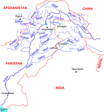
Episode 4B: This is a map of the Indus River basin. Alexander set out from the Hydaspes (Jhelam), moved his fleet to the confluence of the Chenab, where he almost met with disaster because of the current, before finally moving down the Chenab to the Indus.
His total travel distance as a crow flies was somewhat over 1,000 km, and it took him some 8 months to reach the delta.
Alexander’s Indian conquests, with the Mallian campaign taking place around the confluence of the Hydaspes and the Aescines. After the campaign, Nearchus would base his fleet at Patala (Hyderabad) and it is from Patala that he will depart on his epic voyage to the Indian Ocean.
I chose not to go into too much detail with regard to Alexander’s Indian conquests, because this is the history of exploration, and not the history of Alexander, or the history of ancient warfare, after all.
I hope Episodes 4A and 4B did an adequate job setting us up for Nearchus’s journey, which I intend to be the main dish to our Alexander meal.
In this episode, I introduce Nearchus’ early life and voyage with Alexander’s troops into India, and look at the various exchanges which took place between the Meditteranean world and the Indian subcontinent as a result of Alexander’s military forays. The episode ends with Alexander agreeing to his troops’ demands to return to Macedon, and his appointment of Nearchus as admiral to lead a fleet down the Indian ocean and back into Mesopotamia
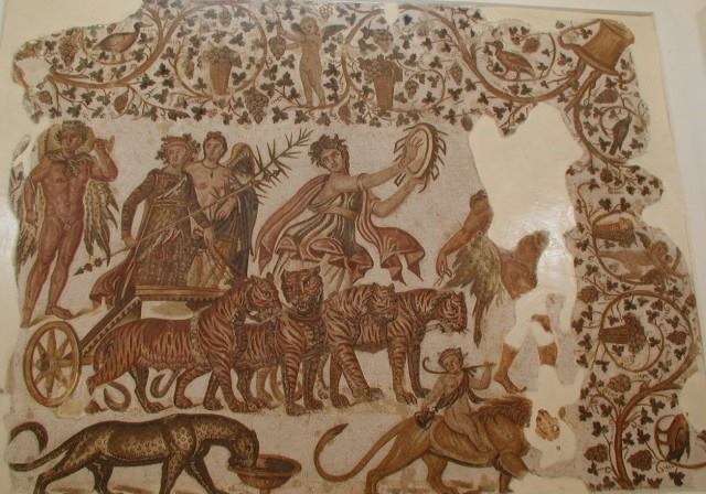
The so-called “Triumph of Dionysus in India” was one of the favorite themes to represent the god, all the way from the early Hellenistic age to the late Roman age.
This is a 3rd century Roman mosaic, found in modern-day Tunisia, that shows this motif in beautiful details. In particular, we can note the cymbals that Dionysus’s follower (a “bacchanal”) is holding, which are an instrument that the Greeks believed the god taught the Indians how to play. In addition, we can see that Dionysus’s chariot is being pulled by 4 tigers, instead of 4 horses. The Mediterranean world had no idea of the existence of tigers before its encounter with India, and they remained an incredibly mysterious and magical animal in the Greek and Roman imagination.
So, why was this episode so difficult?
Well, for some reason, the story of Nearchus, in which we will really sink our teeth in the next episode, has largely been overlooked by modern historians. Apart from a few short summaries of his adventures and life, I could find almost no secondary sources about the man.
Instead, I had to rely almost solely on primary sources (I made heavy use of Arrian and Strabo), as well as on Google Maps to try and find the various locations that he visited. In addition to this being particularly time-consuming, I decided about 10 days ago that context for Nearchus’ journey down the Indus would first be necessary, not only to give a third dimension to the story, but also to explain the mental map that he likely had as he set out with his fleet. Hence, the episode that you have before you today.
I apologize if it is not as “narrative” as I usually aim for my episodes to be. I do hope, however, that you found the connection between Dionysus and India interesting, and that this “first parter” has whetted your appetite for the truly epic adventures that are to come next episode!
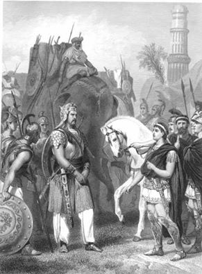
Here is a 19th century engraving of the surrender of the Indian Raja Porus to Alexander, after the battle of the Hydaspes. This was Alexander’s last major battle in his life, and it set the stage for his army’s refusal to continue their march into the Indian subcontinent, as well as for Alexander’s decision to appoint Nearchus in command of his fleet.
In this episode, we follow the second half of Pytheas’ journey as he travels along the western coast of Britain to the far north, where he reports seeing the midnight sun and the congealed sea. We then conclude with an examination of Pytheas’ legacy, and the unfortunate vilification which he experienced at the hands of some historians.
This is the world map elaborated by Herodotus. Although it pre-dates Pytheas’ exploration of northern Europe by some 100 years, this was essentially the mental geographic picture which most educated Greek would have had of the world around 325 BCE. We can see the evolution of knowledge from Anaximander’s first world map.
Notice how the Nile veers wildly off course and ends up in the west?
Yeah, that’s Euthymenes’ fault.
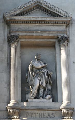
This is the statue of Pytheas that has been placed outside the Palais de la Bourse (which houses the Chamber of Commerce and Industry, as well as a museum) in Marseille, France.
The people of Marseille have really embraced their ancient Greek heritage. Close by to this statue, at the lower end of the La Canebière district of Marseille, near the old port, there is a bronze plaque which reads (translated into English):
“Here around 600 B.C., Greek sailors arrived from Phocaea, a Greek city in Asia Minor. They founded Marseille, from where civilization spread to the West.”
Although this is accurate in the strictly factual sense of the term, one wonders how the Carthaginians and Phoenicians would have felt about Marseille being described as the sole outpost of “civilization” in the Western Mediterranean…
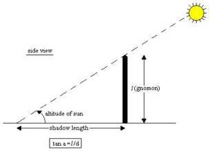
This graph shows the calculations necessary to accurately determine your latitudinal position using a gnomon. In case this is not complicated enough, have a look at the following exerpt from “The Gnomon” at http://mysite.du.edu/~jcalvert/astro/gnomon.htm
“To use the gnomon, set it in the sun and rotate the base so that the shadow of the rod falls on the center line. The scale for reading the length of the shadow must be accurately horizontal, so use the spirit level to make sure of this, shimming the base as necessary with pieces of cardboard. Now, read the length of the shadow on the scale to the nearest millimeter. Note that the end of the shadow is not sharp – why not? – so measure to the center of the penumbra. The altitude of the sun is the arctangent of the ratio of the length of the gnomon to the length of the shadow, easily computed on a scientific pocket calculator. My gnomon can measure altitudes from 28° to 78° , or just about enough to measure the noon elevation of the sun for any date at my latitude of 40° . I should have made the board a little longer, since the minimum solar altitude at noon is 26° . If the board is set accurately north-south on the meridian, local noon occurs when the shadow is on the center line. This is the time to measure the altitude of the sun to determine its declination. When daylight savings time is in effect, noon is really at 1 pm. The sun is not exactly on the meridian at standard time noon, but the difference is not great.”
Confused yet? The fact that Pytheas was able to use a gnomon to repeatedly calculate his position to a very high degree of accuracy shows that he was not only highly educated, but also a skilled practical scientist.
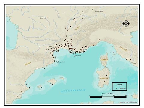
Hi guys! Have a look at this AMAZING map made for us by listener Chris Swanson showing the archaeological finds of amphorae surrounding Massalia, just prior to Pytheas’ departure for Great Britain.
We can clearly see the two riverine trade routes with the Celts at work: one up the Garonne, the other up the Rhone. In addition, we can also see the contacts that the Massalians maintained with the Etruscans, as well as their stymied efforts to extend their influence down the coast of Spain, an area that was gradually being incorporated in the Carthaginian sphere of influence around the time…
The data is taken from Barry Cunliffe’s book: “The Extraordinary Voyage of Pytheas the Greek.”
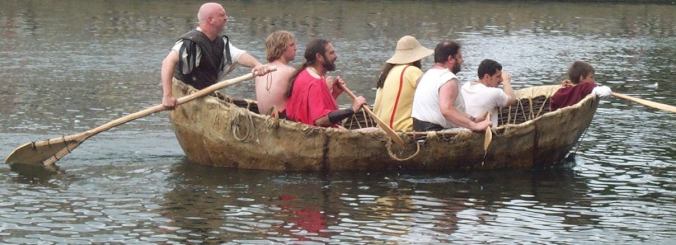
This is a reconstruction of a 1st century AD curragh, smaller than, but similar in structure to the boats in which Pytheas most likely rode as he went north to Thule through the Irish Sea.
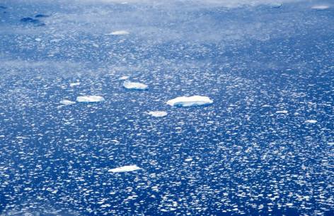
Drift ice along the coast of Greenland. This is probably what Pytheas was referring to when he talked about the “marine lung” and the “congealed sea.” The sight must have been incredibly exotic and confusing for someone used to the warm waters of the Meditteranean.
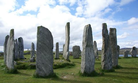
The Callanish Stones, located close to the Western coast of the Outer Hebrides Island of Lewis. It is likely that Pytheas saw these stones, or others like them on the Orkneys and Faeroe Islands. What did he think of them? How did he react to their incredible age? We will never know.